A blueprint for public transporation system development to be carried out in HCM City
|

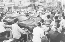
Some observers say that the six million Saigonese and people from elsewhere working and living in HCM City currently own between 3 and 4 million motorbikes of various sizes and capacities. The ever-increasing number of motorbikes-the transport means of every Vietnamese household-is blamed for causing more frequent traffic congestion in the inner city. In addition to measures to curb the growing number of motorbikes, the existing public transportation system must be upgraded to satisfy the transportation demand of the dwellers that are used to driving motorbikes.
The bus system. According to the master plan, bus lines must be established on beltways as well as the city's main routes and streets. From these main routes, secondary bus lines will be set up to complete the entire system. The goal for 2020 is to meet between 25 and 30% of urban dwellers' transport demand. Some bus lines must be prioritized during the 2001-2005 period (see box on page 15).
Coupled with the establishment of the bus routes, it is imperative that administrative measures must be taken to re-distribute the number of people and vehicles in the streets at the same time. The measures consist of offsetting working hours and break times in different zones, imposing toll fees for main streets, and limiting the number of private motorbikes and cars by taxation tools.
The inner city and outer suburbs railroad system. The system would be two loop routes with two lines running across the city. Bus and railroad stations will be installed at intersections of railroads and streets. Intervals between train departure times will be three minutes. Trains will stop at terminals for 60s and at stations for 30s. In the inner city, the distance between two stations is between 1 and 2km while the distance in the outer suburbs is between 2 and 5km. In the future, six railroad routes will be connected to HCM City (see box above).
There will also be two beltway routes and two routes for elevated and underground trains. Part of the latter will be a 25km-long elevated section crossing most of the inner districts with high population density such as Thu Duc, Binh Thanh, Go Vap, Phu Nhuan, and districts 3, 6, 10 and 11. This is the elevated train line to be built during 2003-2010. The second elevated train route which is over 20km long will start at Thu Thiem Station, run past Hai Ba Trung, Phu Nhuan Crossroads, Nguyen Kiem, Nguyen Oanh, Le Duc Tho, and end at Tan Thoi Hiep Terminal. The line consists of both elevated and underground sections.
The subway system. In the city's center, the subway will be mainly underground so that relocation of existing structures can be minimized. In the outer regions, the route can be on the ground or elevated for the sake of lower costs. To meet transportation demands in the central areas, a circle route will start from Le Loi Street, run along Ton Duc Thang, Dinh Tien Hoang, No Trang Long, Phan Van Tri, Tan Son Nhat Airport, Hoang Van Thu, Ly Thuong Kiet, An Duong Vuong, Tran Hung Dao, and end at Le Loi.
There will also be three diametric routes and two herringbone lines. The first diametric route is planed to start at Tan Binh Industrial Park and end at Tan Thuan Export Processing Zone. The route is 19.6km long with 14.6km underground and 5km elevated. The second route starts from Bon Xa Intersection and ends at Thanh Da. This route will cover a distance of 18.1km with 16.6km underground. The third diametric route, which begins at Tan Ky-Tan Quy and ends at Van Thanh, will be 19.3km long with 17.6km underground.
The first herringbone route runs from Hoa Hung Station to Phuoc Kien. It is 8km long, of which 6.5km will be underground. The second herringbone route starts at Hung Vuong Hospital in District 5 and ends at Nguyen Van Linh Street. The route is 7.4km long with 4.1km underground.
The monorail and streetcar systems. Three monorail lines will be put into operation during 2005-2010. They include the 18km Quang Trung Software City-Ben Thanh line; the 29km Suoi Tien-Can Giuoc, and the 10km Tan Binh IP-Cho Lon Interprovincial Passenger Car Terminal.
The Saigon-Cho Lon streetcar line will start at Mien Tay Passenger Car Terminal and end at Thu Thiem Wharf, covering a distance of 13km.
Buses for the bus lines
In late May, HCM City authorities said the Government endorsed a plan to give preferential loans to HCM City to purchase 1,300 new buses. These buses will be chiefly used for the 51 existing bus lines.
The 1,300 buses will be assembled domestically by the Communication & Transport Mechanical Engineering Corporation. Five hundred of the buses will be delivered by the end of this year.
No vehicles allowed
People fond of walking may feel pleased with three pedestrian areas to be set up in downtown HCM City this year. According to a plan prepared by the HCM City Service of Communication and Public Works, sections of Lam Son Square, the area around the Notre-Dame Cathedral, and the park in front of the City Hall will be only for pedestrians. According to the plan, the current bitumen surface will be replaced with paving stones.
Main train routes
The six train routes from HCM City to: (1) Hanoi; (2) Vung Tau; (3) Loc Ninh (to the trans-Asia railroad; (4) Tay Ninh; (5) My Tho and Can Tho; and (6) Nhon Trach - [the future] Long Thanh Airport.
Bus routes of priority:
The East-West route through downtown: Cat Lai - Ha Noi Highway - Dien Bien Phu - Vo Thi Sau - Ba Thang Hai - Hung Vuong (extension).
The North-South route through downtown: Hoc Mon - Cach Mang Thang Tam - Cong Hoa - sections of districts 1, 4 and 7.
The central area - Tan Son Nhat Airport route: Pasteur - Nam Ky Khoi Nghia - Nguyen Van Troi - Truong Son
The Binh Thanh - districts 5 & 8 route: Hoang Van Thu - Ly Thuong Kiet - Nguyen Tri Phuong.
The districts 1 & 5 route: Ben Thanh Market - Tran Hung Dao.
US$10
Billion Required
Huge funding is needed to complete the traffic
and transportation blueprint for HCM City
By Thien Nhan
 HCM City will need an enourmous
funding of over VND150 trillion, or US$10 billion, to complete its traffic
and transportation plans for 2020, according to a blueprint recently
submitted by the municipal Service of Communication and Public Works. More
than half of the funding, some VND86 trillion or US$5.6 billion, will be
needed for 2010.
HCM City will need an enourmous
funding of over VND150 trillion, or US$10 billion, to complete its traffic
and transportation plans for 2020, according to a blueprint recently
submitted by the municipal Service of Communication and Public Works. More
than half of the funding, some VND86 trillion or US$5.6 billion, will be
needed for 2010.
This master plan includes large scale projects such as road systems,
railroad systems for the inner city and outer suburbs, bus and subway
networks, as well as monorail and streetcar systems. The following are the
funding required for some of them.
The East-West Highway and the Thu Thiem Tunnel: requires a total funding
of VND8.1 trillion or US$550 million, of which 85% will be loans from
Japan Bank for International Cooperation. The total length is almost 22km,
including the Thu Thiem Tunnel linking the two banks of the Saigon River.
The tunnel will be 1.6km long with a width of 32.5m and six lanes.
The Saigon-Cho Lon-Mien Tay Passenger Car Terminal: around US$50 million
needed for this project can be obtained from ODA (Official Development Aid),
BOT and the State coffer. The total length is 13km.
The subway and outer suburbs train systems: require a total funding of
US$2.65 billion. The subway system in the inner city will be over 190km